Chase the Horizon on Foot: The Hikes That Redefine ‘Out There’
- SAMPLE ITINERARY
- Dec 1, 2025
- 15 min read
Updated: 4 days ago


If you want to really feel a place—its wild edges, its untamed heart—you don’t drive through it. You walk. And when it comes to world-class hiking, the U.S. cannot be beat. From desert vortexes to alpine epics, mossy East Coast ridgelines to black sand coastlines, this country is laced with trails that go way beyond basic.
In this guide, we’re breaking it down two ways:
First, we’re spotlighting some of our favorite hiking hotspots—compact zones where you can stay in one place, hit a variety of killer day hikes, and still have time for tacos, spas, or a craft beer crawl.
Then, for the ones who want to disappear into the wild for a few days, we’ve got a set of multi-day treks—longer, deeper, wilder routes that bring the full adventure energy.
Pick your pace. Pack your boots. Let’s go.
Hiking Hotspots
The U.S. is stacked with wild pockets where you can drop your bag, stay a while, and let the trails come to you. These are the spots where the hiking’s thick, the food’s local, and the off-trail action hits just as hard. Settle in, head out daily, and soak up everything the terrain—and town—has to offer.
Here are a few hotspots to get your hiking legs twitching.
Hotspot #1:
Red Rock Country, Desert Southwest


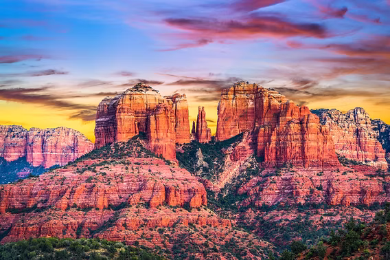
Red rock mysticism, designer yoga mats, and margaritas with Tajín rims.
Welcome to Sedona, Arizona—spiritual playground, geological fever dream, and hiking haven for people who believe in both sweat and sage smudging. Surrounded by massive sandstone monoliths and cut by canyons that feel carved by myth, Sedona’s trail network is tight, accessible, and absurdly photogenic. You can hit 3-4 top-tier hikes in a weekend without ever repacking your bag or losing cell service. Unless you want to, of course.
Some of Our Favorite Trails:
Cathedral Rock – 1.5 mi roundtrip
A short but spicy scramble straight up the sandstone spine of Sedona’s most iconic formation. Hands and feet required. The final saddle viewpoint feels like a cathedral built by tectonics—and yes, the photo ops are unreal. Go for golden hour, and thank us later.
Boynton Canyon + Subway Cave – ~6 mi out-and-back
A meditative trail through red rock cliffs and piney canyon shade, ending with a side adventure to the Subway Cave—a sacred-feeling alcove shaped like a sandstone tunnel. You’ll pass through a vortex zone, so prepare for energy. Bonus: ancient Sinagua ruins along the way.
Soldier Pass Trail – 4.5 mi loop
Packed with geological oddities: the Seven Sacred Pools, a massive sinkhole, and hidden caves tucked into the cliffs. Wildly varied terrain and a touch of Indiana Jones energy. Early start recommended—this one gets traffic and heat.
Doe Mountain – 1.6 mi roundtrip
A quick stair-step climb leads to a flat mesa top with 360-degree views of red cliffs and distant snow-capped peaks. It’s like hiking to your own private helipad. Great for sunrise, and even better with coffee in a thermos and zero plans.
Where to Stay:
Ambiente: A Landscape Hotel – Mirror-clad pods that reflect the terrain—and your inner drama.
L’Auberge de Sedona – Creekside cabins with outdoor showers and champagne brunches.
Where to Eat:
Elote Café – The cult-favorite. Mole that will wreck your standards.
The Hudson – Casual-luxe with canyon views and killer cocktails
Indian Gardens Café – Breakfast burritos that fuel a five-mile ego
More to Do:
Jeep tour with metaphysical detour: local guides will take you to vortexes, tell you your aura color, and somehow still be cool.
Art crawl in Tlaquepaque
Stargazing on Airport Mesa – Bring a blanket and a warm body
Hotspot #2:
Northeast, Mount Mansfield & Green Mountains


Covered bridges. Fog-tipped pines. And trails that feel like they’ve been waiting 200 years for you to show up with a flannel and a flask.
Tucked in the northern spine of Vermont, Stowe is where New England goes to flex—mountains draped in foliage, trailheads that double as historical landmarks, and locals who know their IPA from their IPA-hype. Base yourself in this mountain town and you’ll have trail after trail spilling out in every direction—each one a little mystical, a little moody, and a lot less crowded than they should be.
Some of Our Favorite Trails:
Sterling Pond Trail – 2.5 mi out-and-back
A short, uphill punch that deposits you at the edge of Sterling Pond, a still, glassy mountain lake hidden behind thick trees and boulder fields. Come early to catch the fog curling off the water—or stay late and skinny dip like no one’s watching.
Stowe Pinnacle Trail – 3.7 mi roundtrip
A steady, leg-burning climb through dense forest that breaks open at the top into one of the most photogenic panoramas in the Northeast. Think: patchwork valleys, distant peaks, and wind in your hair. Popular, but for good reason.
Sunset Ridge Trail to Cantilever Rock – ~5 mi roundtrip
A little longer, a lot more drama. This trail hugs the ridgeline of Mount Mansfield and delivers sweeping views all the way up to Cantilever Rock—a gravity-defying stone ledge that juts out like a launching pad for your existential crisis. Good on cloudy days too, when the fog makes it feel haunted.
Moss Glen Falls Trail – ~1 mi roundtrip
Short. Sweet. Waterfall-loaded. This trail is more of a jaunt than a hike, but the payoff is a 125-foot stunner that crashes into a mossy gorge like it’s auditioning for a shampoo commercial. Easy win with max aesthetic return.
Where to Stay:
Edson Hill – Cozy-chic inn with wood-burning fireplaces and horse stables
Field Guide Lodge – Boutique and millennial-approved, with vintage ski-lodge flair
Where to Eat:
Plate – California-meets-Vermont, seasonal and stylish
Doc Ponds – Craft beer, vinyl on the turntable, and fried chicken that messes with your morals
Butler’s Pantry – The brunch. That’s it.
More to Do:
Trapp Family Lodge (yes, those von Trapps): mountain biking, beer garden, Austrian vibes
Spa at Topnotch Resort – Hot stone massage with a side of mountain views
Ben & Jerry’s Factory Tour (because chaos deserves ice cream)
Hotspot #3:
Cascade Lakes Scenic Byway & Deschutes National Forest


Volcanoes. Wildflower-strewn alpine lakes. And a town where your barista probably outruns you on the weekends.
Bend, OR is where high desert meets high elevation. It’s the kind of place where your day might start with a sunrise summit, roll into an alpine lake swim, and end with a pint at a brewery that has more hops than humility. The trails here are ridiculously diverse—lava caves, waterfall loops, backcountry epics, and gentle recovery strolls all live within a 30-minute radius.
Some of Our Favorite Trails:
Green Lakes Trail – 9 mi out-and-back
The crown jewel. This forested route follows Fall Creek past cascading waterfalls and wildflower meadows before delivering you to Green Lakes—a string of turquoise stunners nestled below South Sister’s snowy flanks. It’s popular, but worth every step. Go early to beat the crowds and catch reflections that look like CGI.
Tam McArthur Rim Trail – 5.5 mi roundtrip
This one’s a flex. A high-altitude, ridge-running climb that starts at Three Creeks Lake and ascends to sweeping views of the entire Cascade Range. On a clear day, you’ll see as far as Mount Hood to the north and Broken Top looming in front of you like a cracked crown. Short, but dramatic—your legs and lungs will feel it.
Lava River Cave – 1.5 mi roundtrip
Descend into the belly of a lava tube, headlamp strapped tight, and walk through a mile of cool, echoing darkness. It’s weird, it’s quiet, it’s 40 degrees even when it’s 90 outside. A total shift in atmosphere and a great midday escape from the heat.
Benham Falls + Lava Island Trail – ~2–4 mi, choose your loop
A breezy riverside trail with low effort and high drama—think Class V rapids, lava rock formations, and pine-scented paths that hug the Deschutes River. Easy on the legs, big on views. Perfect for late starts or a half-day wind-down.
Pilot Butte – ~1.8 mi roundtrip
Yes, it’s in town. Yes, it’s a volcano. And yes, you can climb it before breakfast. A short, steep spiral to a summit with 360-degree views of Bend, the Cascades, and the desert beyond. Go at sunrise with a coffee or at sunset with a flask.
Where to Stay:
SCP Redmond – Stylish, sustainable, and 20 minutes from Bend. Rooftop yoga, plant-forward café, and that whole minimalist aesthetic that says “I hike and compost.”
Campfire Hotel – Retro-motel revival in Bend with fire pits, a pool, and real personality.
Tetherow Resort – Luxe but lowkey, with insane mountain views and a golf course if you want to pretend to relax.
Where to Eat:
Jackson’s Corner – Local produce, sourdough everything, line out the door for a reason.
Spork – Globally-inspired small plates, bold flavors, zero fuss.
Bosa Food & Drink – Elevated Italian in a relaxed, woodsy setting.
The Lot – Food carts, fire pits, rotating beer taps. Bend in a nutshell.
More to Do:
Float the Deschutes River through downtown Bend with a cooler and questionable decisions.
Boneyard Beer or Crux Fermentation Project for post-hike pours.
High Desert Museum – Surprisingly wild. Raptors, otters, and the weird, rugged story of this part of Oregon.
Smith Rock State Park (40 mins away): World-famous climbing mecca + dramatic day hikes like Misery Ridge Trail (the name is accurate and perfect).
Day trip to Sisters – A tiny Old West town reimagined by artists, ranchers, and mountain bikers. Shop indie gear boutiques then catch golden hour on Three Creeks Road.
Multi-Day Treks
Ever dream of tossing on a pack and ghosting real life for a few days? The wilderness is calling—and if you really want to hear it, you’ve got to disappear into it. That means long miles, sore legs, and the kind of trail-fueled clarity you can’t buy in a bottle.
The U.S. is stitched together with legendary long-distance trails—the Pacific Crest Trail, the Appalachian Trail, and dozens of other wild paths that beg to be broken into bite-sized, multi-day adventures. You don’t need to go full thru-hiker to feel the magic—just commit to a few days off-grid, on-foot, and fully immersed.
What follows: a curated collection of longer treks worth chasing, complete with ideas for where to stay, eat, and decompress—before, during, or after the trail.
Heads up: These routes are built for seasoned hikers. If it’s been a minute, maybe don’t start here. Or do—but bring snacks, grit, and a damn good exit plan.
Trek #1:
PCT Teaser: Mount Laguna to Warner Springs, CA
Total Distance: ~40 over 3 days


The Pacific Crest Trail is America’s most seductive slow burn—2,650 miles of dirt path winding from Mexico to Canada through deserts, high Sierra, and volcanic Cascade peaks. Thru-hikers spend months chasing snowlines, chasing water, and mostly chasing their sanity. But here’s the secret: You don’t need to walk the whole thing to feel its magic.
This 3-day, ~40-mile stretch from Mount Laguna to Warner Springs is where the PCT flirts with the Southern California backcountry in a way that’s equal parts rugged and romantic. Expect pine forests that smell like heaven, wide-open desert overlooks, and mornings that arrive in full Technicolor.
With this trek, you’ll experience a hit of high-country euphoria—without quitting your job, selling your car, or getting a trail name like “Toe Blister.”
Leg 1: Mount Laguna to Sunrise Trailhead
Distance: ~13 miles
This leg eases you into it. You start at over 6,000 ft in Mount Laguna, enveloped by tall pines, breezy ridgelines, and that sky. The trail tiptoes along the Laguna Mountains, dropping stunning views over the Anza-Borrego Desert far below. It’s quiet, cinematic, and sets the tone: you’re out here now.
Points of Interest:
• Desert Overlook Ridge: Endless drop-off views of the desert floor
• Big Laguna Trail Junctions: Meadows, wildflowers, and forest contrast
• Sunrise Trailhead: Your Leg 1 exit point near the road
Eat:
• Pre-hike: Grab a hearty breakfast at Pine House Café & Tavern in Mount Laguna (coffee, eggs, and the kind of breakfast burrito that doesn’t quit)
• On the trail: Trail snacks—think protein bars, jerky, dried fruit. Water sources are scarce, so load up in town.
Stay:
• Night before: Stay at the Laguna Mountain Lodge for cozy, cabin-style vibes right in the village
• End of Leg 1: You’ll need to camp near Sunrise Trailhead—there are flat spots off-trail to pitch for the night, or shuttle into Julian if you’re feeling soft.
Leg 2: Sunrise Trailhead to Barrel Spring
Distance: ~14 miles
The scenery shifts hard here. Forests fade to chaparral. The sun hits different. You’ll follow long ridgelines with views that punch straight into the Anza-Borrego badlands—raw, exposed, and utterly alien. This section is big on solitude and big on desert drama.
Points of Interest:
• Chihuahua Valley Overlooks, a series of dry creek crossings and cactus gardens
• Barrel Spring, a known water cache and camping spot for thru-hikers
Eat:
• Trail meals: Dehydrated meals, cold-soaked couscous if you're getting crunchy. Pack all food in—there’s no resupply until Warner Springs.
• Tip: If you arrange a support shuttle or cache drop (PCT hack), you might be able to snag a mid-trail sandwich. Otherwise? DIY it.
Stay:
• Camp at Barrel Spring—flat spots and thru-hiker camaraderie. Watch the stars. Try not to cry about your knees.
Leg 3: Barrel Spring to Warner Springs
Distance: ~13 miles
The final day coasts through rolling grasslands, wild oaks, and the kind of golden California dreamscape that feels too cinematic to be real. The high desert softens into fertile valley, and the final miles feel like a fever dream—especially as the PCT snakes through cow pastures and across wide meadows into Warner Springs.
Points of Interest:
• Eagle Rock: A natural rock formation shaped like—yep—an eagle
• Meadow walking: Golden-hour gold
• Warner Springs Community Resource Center (legendary among PCT hikers)
Eat:
• Trail: Final snacks. Maybe that crushed Pop-Tart you forgot in your pack.
• Post-hike brunch in Julian (short drive from Warner Springs):
• Manzanita Diner: Brunch like a local—if the locals were all trail-hardened poets.
• Mom’s Pies: Apple crumb that erases all memory of foot pain.
Stay:
• Post-hike recovery at Sacred Sands (outside Joshua Tree, ~2 hrs drive): Think mirror pools, incense, outdoor tubs, and stars that’ll make you rethink your existence.
• Or if that’s too far: Airbnb in Julian, or a rustic inn like Julian Gold Rush Hotel for small-town charm with a side of ghost story.
Trek #2:
Appalachian Snapshot – Roan Highlands Loop, NC/TN Border
Total Distance: ~20–25 miles over 2–3 days


The Appalachian Trail is America’s most soul-searchy footpath. It’s mossy, moody, and messes with your mind in all the right ways.
But the Roan Highlands? This stretch turns the southern Appalachians into a stage—bald summits, rolling ridgelines, and cloud-slicing panoramas that rival anything in the West.
This 2-3 day loop gives you a hit of high-elevation magic with zero need to renounce shampoo. And the Roan Highlands are one of the most photogenic, walkable ridgelines on the entire AT—especially in spring when the wildflowers pop like confetti. It’s full of Rhododendrons, fog banks, and the kind of wild, windswept energy that makes you want to delete your inbox.
Leg 1: Carver’s Gap to Grassy Ridge Bald (then loop toward Bradley Gap)
Distance: ~8 miles
Start at Carver’s Gap, already 5,500 ft up, and stroll straight into magic. You’ll cross a series of bald summits—Round Bald, Jane Bald, and Grassy Ridge Bald—that serve skyline views all day long. No tree cover, no filter needed. Just ridgeline swagger and big sky drama.
Points of Interest:
• Round Bald – Your intro summit with full 360°s
• Jane Bald – Short but steep and cinematic
• Grassy Ridge Bald – Highest of the trio and perfect for a long, smug lunch break
• Roan High Knob Shelter – Optional side trip for the highest shelter on the AT
Eat:
• Pre-hike fuel: Grab breakfast at Mountain Harbour B&B near Roan Mountain—yes, they do a trail-famous hiker’s breakfast buffet
• On the trail: Picnic on the balds with pre-packed snacks, hard cheese, cured meats, and wildflower views
Stay:
• Night before: Book a room or bunk at Mountain Harbour B&B—they also offer shuttles and trailhead parking
• Camp: Pitch at designated backcountry sites near Bradley Gap or Little Hump Mountain—open sky, soft grass, stars for days
Distance: ~7–9 miles
This leg dips in and out of forest and returns you to more bald-topped euphoria. The ascent to Little Hump Mountain is steep, but the payoff? A windswept summit that feels like Scotland. You’ll also cruise through Yellow Mountain Gap, rich in Revolutionary War history and wild Appalachian mythos.
Points of Interest:
• Little Hump Mountain – Wild, wide-open, always windy
• Overmountain Trail junction – History and views converge
• (Optional) Overmountain Shelter site – iconic red barn turned hiker haven (now closed, but still worth the vibe)
Eat:
• On the trail: Keep it light—trail mix, jerky, energy chews.
If you're doing a supported trek, arrange a midpoint resupply picnic at Yellow Mountain Gap (local outfitters can help with this.)
Stay:
• Camp: Sites near the old Overmountain Shelter zone—still a legendary spot with sunrise photo ops and a gentle creek nearby.
Leg 3: Overmountain Area to Carver’s Gap (via AT Loop or side trails)
Distance: ~6–8 miles
Your final day loops you back toward Carver’s Gap, either retracing some of your route or detouring via the AT side trails through Roaring Fork or the Cloudland Hotel site. Either way, the trail descends gently and offers one last look at those wild, rolling summits. Fog often creeps in, giving the return leg a mystical, floating-through-the-clouds energy.
Points of Interest:
• Cloudland Hotel site ruins – A vanished 1800s luxury resort on Roan Mountain’s summit
•. Roaring Fork Trail – A quieter route with lush forest vibes
Eat:
• Trail snacks to coast home
• Post-hike meal:
• The Dining Room at Gideon Ridge Inn (Blowing Rock) – White tablecloths, Blue Ridge views, and refined Southern cuisine
• Stick Boy Bread Co. (Boone) – Load up on sandwiches, pastries, and real coffee
Stay:
Boone Basecamp Options:
• The Horton Hotel – Downtown boutique with rooftop bar and real bed energy
• Inn at Crestwood – A spa lodge nestled in the woods if you need eucalyptus and a deep tissue reset
Trek #3:
Alpine Spell – The Enchantments Core Zone, WA
Rugged alpine. Crystal lakes. Goats, granite, and your legs screaming in cursive.
Distance: ~20 miles over 3–4 days (Stuart to Snow Lakes direction recommended for more gradual descent)


Welcome to the Enchantments—Washington’s most coveted alpine arena and a backcountry bucket list hike that actually lives up to the hype. Nestled in the Stuart Range near Leavenworth—a Bavarian-style mountain town where the bratwurst is legit—the Enchantments serve up granite basins, icy turquoise lakes, and shaggy mountain goats like some kind of Tolkien-meets-North-Face fever dream.
The full Core Zone is permit-only (lottery system, and yes, it’s intense), but if you get in, you’re looking at 3–4 days of high-elevation wilderness perfection. The hike runs point-to-point from Stuart Lake Trailhead to Snow Lakes Trailhead, with about 20 miles and a soul-punching 4,500+ ft of gain. You’ll work for it. And you won’t shut up about it for years.
It’s one of the most iconic multi-day hikes in the U.S.—wild, pristine, and protected by the pain of actually getting there.
Leg 1: Stuart Lake Trailhead to Colchuck Lake
Distance: ~4.2 miles
Start at Stuart Lake Trailhead, just a short drive from Leavenworth. From there, climb steadily through pine forest, streams, and alpine glow until you hit Colchuck Lake—a glacial stunner nestled beneath the sharp fang of Dragontail Peak. Colchuck isn’t technically inside the Core, but don’t tell her that. She looks like she owns it.
Points of Interest:
• Bridge over Mountaineer Creek
• Colchuck Lake – Unreal color. Unreal backdrop. Swim if you're brave.
Eat:
• Pre-hike meal: Grab baked goods and trail snacks from Argonaut Coffee & Biscuits in Leavenworth. Load up.
• Trail food: Light first-day snacks and something worthy of a lakeside dinner—ramen, smoked salmon, or that overachieving dehydrated curry.
Stay:
• Camp at Colchuck Lake – Designated backcountry zones near the lake. Early arrival helps secure a spot. Sleep beneath Dragontail’s shadow and let the mountain goats judge you from a distance.
Leg 2: Colchuck Lake to the Enchantments Core (via Aasgard Pass)
Distance: ~2 miles (but brutal gain—2,000+ ft in 0.8 miles)
The most infamous section of the trek: Aasgard Pass. This is a near-vertical scramble up a boulder field that will test your legs, your pack, and your will to go on. But once you crest it? You're in the Upper Enchantments, and it’s like stepping into another dimension. Basins of melted glacier, rock formations like sculptures, and goats that act like they own the lease.
Points of Interest:
• Aasgard Pass – Bring microspikes if there’s snow. No shame in slow.
• Tranquil lakes: Isolation, Inspiration, Perfection, and Crystal—yes, those are real names. Yes, they live up to them.
• Leprechaun & Gnome Lakes – Smaller, magical, and usually quieter.
Eat:
• Trail food only—cold-soak if you’re fancy, but this is a “reward with chocolate” kind of day.
• Hydration is key—electrolytes save lives here.
Stay:
• Camp in the Core Zone – If you snagged a permit, there are multiple designated zones. Perch yourself near Inspiration Lake for sunrise reflections that break your brain.
Leg 3: Core Zone to Snow Lakes Trailhead
Distance: ~13 miles
This leg rolls through the Lower Enchantments, losing elevation slowly past more stunning lakes—Viviane, Snow Lake, and Nada Lake—before switchbacking forever down to the Snow Lakes Trailhead. This is the long descent: tough on knees (what hiking poles are for), easy on eyes.
By the time you reach Nada Lake, it’s pure forest vibes and cool creek crossings. From the trail’s end, Leavenworth is just a 15-minute drive—easy to reach if you’ve arranged a shuttle or parked a second car.
Points of Interest:
• Lake Viviane – Granite-framed and perfect for a break
• Snow Creek Wall – A massive rock face popular with climbers
• Nada Lake – A sweet final sendoff before the slog
Eat:
• Trail snacks all the way down. You’ll need them—this descent is no joke.
• Post-hike:
• Yodelin Broth Co. – Get the bone broth ramen and a cider.
• Blewett Brewing – Pizza + beer = rebirth.
Stay:
• LOGE Leavenworth – Trail-adjacent, mountain-hip, and hammock-ready
• Posthotel Leavenworth – Adult-only spa escape with Alpine luxe vibes and outdoor soaking tubs. You earned this.
Ready to build a truly epic hiking adventure?
We’ve got the ideas and the hookups. Reach out to see what we can build together.